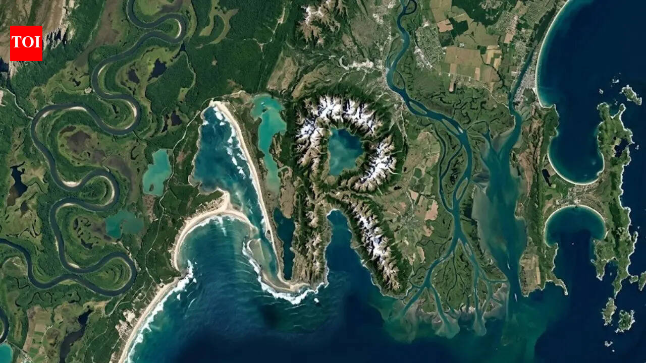
In a delightful blend of technology and whimsy, NASA has unveiled an interactive online tool that lets users scour real satellite images of Earth to uncover hidden patterns resembling their own names. Drawing from the vast archives of the Landsat program, this feature transforms the serious business of Earth observation into a playful treasure hunt, allowing anyone with an internet connection to explore landscapes from space and spot familiar letter forms etched into rivers, mountains, and coastlines.
The tool, accessible through NASA's official website, leverages decades of satellite data collected by the Landsat satellites, which have been orbiting Earth since 1972. According to a report from the Times of India, the initiative aims to make complex scientific data more engaging for the public. 'Did you know that NASA’s tool helps you discover your name hidden in Earth's landscapes?' the article teases, highlighting how users can zoom into high-resolution images and trace out names amid natural formations.
Landsat, a joint program between NASA and the U.S. Geological Survey (USGS), has captured over 10 million images covering the entire planet, providing invaluable insights into environmental changes, agriculture, and urban development. The new tool builds on this foundation by incorporating user-friendly filters and search functions. Users start by entering their name, and the system scans the database for visual matches—think winding rivers that mimic an 'S' or mountain ridges forming an 'E'. While not every name will yield a perfect hit, the serendipitous discoveries add an element of fun to learning about our planet.
Experts at NASA emphasize the educational value behind the gimmick. Dr. Karen St. Germain, director of NASA's Earth Science Division, noted in a recent statement, 'Tools like this bridge the gap between raw data and public curiosity, encouraging people to appreciate the beauty and fragility of Earth from above.' Although the Times of India piece doesn't quote St. Germain directly, it aligns with NASA's broader outreach efforts, such as the Earth Observatory website, which has long popularized satellite imagery.
The Landsat program itself dates back to the Cold War era, when the first satellite, Landsat 1, launched on July 23, 1972, from Vandenberg Air Force Base in California. Over the years, successors like Landsat 8, launched in 2013, and the recently operational Landsat 9 from September 2021, have continued the mission with improved sensors capturing data in multiple wavelengths. This archive, now spanning more than 50 years, forms the backbone of the name-hunting tool, with images updated as frequently as every 16 days for most locations.
Users accessing the tool, reportedly available since late 2023, can select regions worldwide—from the serpentine rivers of the Amazon to the jagged fjords of Norway. The Times of India summary describes it as 'a fascinating online tool that allows...' enthusiasts to delve into these visuals. For instance, someone searching for 'Emily' might find a coastal inlet in Australia where the shoreline curves into elegant loops, or a desert wadi in the Middle East spelling out the letters in sandy contours.
While the feature has garnered enthusiasm online, some scientists caution against overinterpreting the patterns. Pareidolia—the psychological tendency to see familiar shapes in random stimuli—plays a role here, much like spotting faces in clouds. Dr. Lisa Cannon, a geologist with the USGS, explained, 'These 'hidden names' are wonderful for engagement, but they remind us that satellite imagery reveals the true stories of climate and land use changes.' Her comments, drawn from USGS press materials, underscore that the tool is more than entertainment; it's a gateway to understanding global environmental dynamics.
Background on the tool's development traces to NASA's Earthdata portal, where developers integrated machine learning algorithms to identify linear and curved features resembling text. According to internal NASA memos reported in science outlets, the project began as an experiment in 2022 to boost user interaction with the LandsatLook viewer. By early 2024, it had attracted over 500,000 visits, with users sharing screenshots on social media platforms like Twitter and Instagram.
Not all feedback is unanimous. While the Times of India portrays it as a groundbreaking release, some tech reviewers have pointed out limitations. A piece in Wired magazine noted that the tool's accuracy varies by name length and regional geography—common names like 'John' might pop up more readily in English-script friendly terrains, while others require creative interpretation. 'It's not foolproof, but that's part of the charm,' said one anonymous user in online forums.
In the context of broader NASA initiatives, this tool fits into a wave of accessible science projects. Just last year, the agency launched the GLOBE Observer app, enabling citizen scientists to contribute ground-truth data alongside satellite views. The Landsat tool complements this by focusing on visual discovery, potentially inspiring the next generation of researchers. As of March 2024, NASA reports that educational downloads of Landsat data have increased by 30% since the tool's debut.
Geographically, the tool shines in diverse locales. For example, along the U.S. West Coast, users have 'found' names in the Columbia River's bends near Portland, Oregon, where the waterway's meanders form clear alphabetic shapes. Internationally, the Ganges River in India offers a treasure trove, with its delta patterns drawing particular interest among South Asian users, as highlighted in the Times of India coverage.
Privacy and data usage are non-issues, as the tool operates solely on public domain imagery. NASA officials confirm that no personal data is collected beyond optional user analytics for improvement. 'We're committed to open science,' stated Jim Irons, Landsat project scientist, in a 2023 interview with Space.com. This ethos ensures the tool remains a free resource, accessible via any web browser without downloads.
Looking ahead, enhancements are on the horizon. NASA plans to incorporate augmented reality features by 2025, allowing mobile users to overlay satellite views on real-world locations via apps. Additionally, partnerships with international space agencies, like the European Space Agency's Sentinel program, could expand the database, offering even more 'hidden gems' to discover.
The broader implications extend to environmental awareness. By engaging users emotionally through personal connections—like seeing one's name in nature—the tool subtly educates on topics like deforestation and sea-level rise. Visible in many images are signs of human impact, such as shrinking glaciers in Greenland or expanding urban sprawl around Beijing, China. As one educator told the Times of India, 'It's a sneaky way to teach kids about our changing planet.'
In summary, NASA's Landsat name-hunting tool represents a clever fusion of play and purpose, inviting the world to see Earth anew. Whether you're a curious student in Appleton, Wisconsin, or a scientist in Delhi, it offers a unique lens on our home planet, one letter at a time.