As the Atlantic hurricane season officially draws to a close on November 30, researchers are reflecting on a year they describe as unusually unpredictable, marked by intense storms, a surprising lull in activity, and no direct hits on the U.S. mainland for the first time in a decade. Atmospheric scientist Phil Klotzbach of Colorado State University called it a "screwball" season, filled with anomalies that defied typical patterns even as climate change continues to amplify storm ferocity.
"It was just a strange year," Klotzbach said. "Kind of a hard year to characterize." The season, which runs from June 1 to November 30, produced only five named hurricanes—Erin, Gabrielle, Humberto, Imelda, and Melissa—but four of them reached major status, classified as Category 3 or higher with sustained winds of at least 111 mph. Three escalated to Category 5, the maximum intensity level on the Saffir-Simpson scale.
Forecasters had anticipated an above-average year. In May, the National Oceanic and Atmospheric Administration predicted six to 10 hurricanes, with at least three becoming major storms. Klotzbach's independent forecast aligned closely, as did estimates from other tracking groups. Yet the lower-than-expected number of storms still resulted in a season deemed above normal, thanks to a key metric known as accumulated cyclone energy, which measures the combined strength and longevity of tropical systems.
Klotzbach had forecasted accumulated cyclone energy at 125% of the 30-year average; the actual figure landed at 108%. "It was a quality season, not a quantity season," he explained, highlighting how the fewer storms that formed carried exceptional power. Brian McNoldy, a hurricane researcher at the University of Miami's Rosenstiel School of Marine, Atmospheric, and Earth Science, noted that the ratio of major hurricanes to total hurricanes was the highest in the past 50 years.
"That’s the highest ratio there’s been in the past 50 years," McNoldy said. This intensity aligns with broader trends linked to a warming climate. Nine of the past 10 Atlantic hurricane seasons have exceeded normal activity levels, according to Klotzbach, who attributes the pattern to elevated ocean temperatures and the influence of La Niña, a climate phenomenon that reduces upper-level winds that can disrupt storm formation.
Atlantic sea surface temperatures in 2025 were "anomalously warm," McNoldy reported, providing abundant fuel for any storms that did develop. Hurricanes require ocean waters of at least 79 degrees Fahrenheit to form, and the heat drives evaporation, lifting warm, moist air to spark convection. This year's conditions allowed for rapid intensification in several cases. For instance, Hurricane Erin saw its maximum sustained winds increase by about 75 mph in just 24 hours, while Melissa surged from a tropical storm to a Category 4 hurricane over the same timeframe.
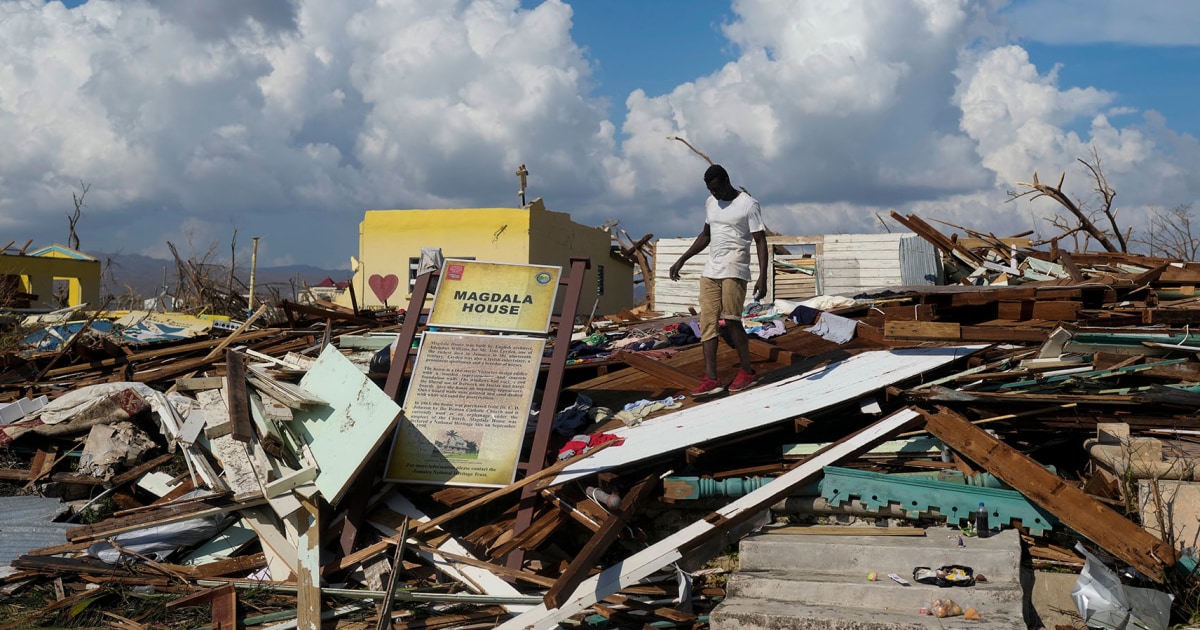
"Both are 'really, really exceptional' rates of intensification," McNoldy said. Melissa stands out as one of the most powerful storms ever recorded, tying the 1935 Labor Day hurricane—the deadliest in U.S. history, which struck the Florida Keys—with sustained winds of 185 mph at landfall. Melissa also recorded a gust of 252 mph, according to data from the National Hurricane Center.
Despite these powerhouses, the season had its quiet moments, particularly during what is usually the busiest period. Activity typically peaks in late August and early September, but this year, the Atlantic basin went silent for about three weeks, from August 24 to September 16, with nothing of significance forming. Klotzbach noted that this was the first such extended lull during peak season since 1992.
"For about three weeks during the peak of the season, it was completely dead," McNoldy said. Researchers do not see this as the start of a new pattern. Last year's similar slowdown was attributed to storms forming too far north to gain momentum across the Atlantic, Klotzbach explained. In 2025, the eastern Atlantic remained stable and dry, conditions that stifled development.
"That we had two quiet peak seasons in a row is certainly strange, but I think it’s just a coincidence," McNoldy added. The unpredictability extended to storm paths as well. For the first time since 2015, no hurricanes made landfall on the continental U.S., sparing coastal communities from direct impacts. However, that outcome hinged on a dramatic meteorological interaction involving Hurricane Imelda.
In September, Imelda approached the U.S. East Coast as a tropical storm, prompting forecasts of heavy rain and potential flooding in the Carolinas. But hundreds of miles offshore, the massive Category 5 Hurricane Humberto exerted influence through the Fujiwhara effect, a rare phenomenon where two vortices orbit a common center, often causing the weaker storm to be drawn into the stronger one. This interaction steered Imelda sharply away from land.
"Had Humberto not been there, Imelda was probably a big flooding story," Klotzbach said. McNoldy described it as "another crazy aspect of the season." While the U.S. dodged direct hits, other regions were not so fortunate. Melissa's landfall, though not on U.S. soil, underscored the global reach of these intensified systems, tying a record set nearly 90 years ago during the Great Depression era.
Amid the season's twists, advancements in forecasting offered a bright spot. The National Hurricane Center's written updates for Melissa frequently referenced "Google DeepMind," an artificial intelligence tool that proved pivotal in predicting the storm's rapid strengthening. Developed by Google, the model was released to the public in June and quickly demonstrated superior performance.
McNoldy evaluated error rates across more than 10 forecasting models and found DeepMind among the top performers for both track and intensity predictions. "It was a model that was just put out in the public eye in June, and it outperformed the other conventional models for track and intensity, which is unheard of, to have something right off the shelf new be that good," he said. "It’s hard to not to be optimistic about it."
This season's surprises serve as a reminder of hurricanes' inherent unpredictability, even as tools like AI enhance preparedness. In a warming world, where warmer oceans are expected to fuel more intense storms, experts like Klotzbach and McNoldy emphasize the need for continued vigilance. Late-season formations, such as those seen in 2025, may become more common, but the exact timing and paths remain elusive. As communities assess the year's lessons, the focus shifts to refining models and resilience strategies ahead of 2026.