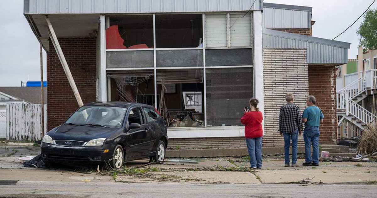
KANSAS CITY, Kan. — A sudden outbreak of tornadoes struck areas southwest of Kansas City on Monday night, catching residents and forecasters off guard and injuring at least three people while damaging homes and overturning recreational vehicles. The event, which included at least five twisters, has reignited concerns among meteorologists about potential gaps in forecasting due to recent changes at the National Weather Service, including delayed weather balloon launches amid ongoing staffing shortages.
According to preliminary reports from the National Weather Service, the strongest of the tornadoes was rated EF2 on the enhanced Fujita scale, with wind speeds reaching about 125 mph. Trees were uprooted, and several structures sustained significant damage in the affected areas. The Storm Prediction Center, responsible for forecasting severe thunderstorms and tornadoes, did not include the Kansas City region in its Monday afternoon outlook for potential tornado threats, a omission that has drawn scrutiny from outside experts.
The tornadoes developed rapidly, prompting the weather service to issue a tornado watch at approximately 6:35 p.m., about 30 minutes before the first twister touched down. Local offices in Topeka, Kansas, and Kansas City, Missouri, followed with several warnings as the storms intensified. Tornado watches signal favorable conditions for twister formation, while warnings indicate a tornado has been detected or is imminent, typically providing around 15 minutes of advance notice based on research.
Meteorologists outside the agency have pointed to a shift in the timing of weather balloon releases as a possible factor in the forecasting disconnect. Traditionally, balloons are launched at more than 100 sites across the U.S., including the Great Plains, at 7 a.m. and 7 p.m. local time to gather critical data on temperature, humidity, and wind speeds in the upper atmosphere. However, on Monday, many offices in the region delayed the morning launch until noon, reportedly due to staffing constraints.
“We are missing data at the normal times,” said Chris Vagasky, a meteorologist and research manager at the Wisconsin Environmental Mesonet, a statewide network of weather monitoring stations. He explained that the staggered schedule created a “big area over the southern Plains in the central United States without that weather balloon data, which might have caused the models to not forecast the day’s activity as well as it could have.”
Weather balloons, equipped with radiosondes that transmit atmospheric measurements back to the ground, are essential for predicting storm tracks, which often move from west to east across the country. The data informs forecasting models that run on fixed schedules, including those shortly after 7 a.m. With Monday's delays, key information from regions like the Four Corners, northern Plains, and central Plains—where the storms originated—was unavailable for those early runs.
“You’re missing data from the Four Corners region, from the northern Plains, from part of the central Plains, and that’s where the storms were developing,” Vagasky added, highlighting the potential ripple effects on predictions downwind.
Alan Gerard, a retired meteorologist who served as director of analysis and understanding at NOAA's National Severe Storms Laboratory until last year, attributed the schedule changes to persistent staffing issues. “They’ve been deferring them to the day shift — midday — for when they have more staff,” he said. Gerard called for a formal study, noting, “It’s like we’re conducting a real-time experiment without any way to evaluate what the impacts of it are.”
The staffing shortages trace back to cuts implemented by the Trump administration last year, which included buyouts and the termination of probationary employees. These measures left some forecasting offices understaffed, leading to halted or delayed balloon launches at various locations. While the weather service has since recruited to address the gaps, experts say the challenges persist, especially as tornado season ramps up in late April and May.
In response to the concerns, Erica Grow Cei, a spokesperson for the National Weather Service, defended the agency's forecasting capabilities. “NOAA’s weather model performance has not been impacted by any changes to the schedule of our twice-daily radiosonde (weather balloon) launches,” she said in a statement. Cei pointed to evaluations by NOAA’s Environmental Modeling Center, which reportedly show no degradation in model performance, with findings available on the center’s website.
Local forecasters in Kansas City acknowledged the volatile atmosphere on Monday but had assessed the risk of storm development as low. “There was a pretty strong possibility there would be no showers or thunderstorms at all — you’d have a primed environment where nothing ever develops or nothing happens,” said Brad Temeyer, a meteorologist at the Kansas City office. He described the event as a “low-probability event of it occurring, but given that it did occur, it had high impact.”
Temeyer noted that the office conducted damage surveys on Tuesday and found no fatalities, with residents generally prepared. “We didn’t have any significant injuries or fatalities, and in going out and doing the storm surveys today, everybody said they were prepared for potential tornadoes and took shelter once those warnings were in effect,” he said. For the Kansas City area, he urged continued vigilance amid expectations of more severe weather in the Midwest through the weekend.
The Kansas incident echoes a deadly tornado event in southern Michigan last month, where four people were killed and no advance watch was issued, though warnings were sent out as twisters approached. Democratic Sens. Gary Peters and Elissa Slotkin of Michigan questioned National Weather Service Director Ken Graham in a letter about the lack of a watch, possible staffing roles, and plans for better alerts. The agency responded directly to the senators but did not disclose the details publicly.
Brian LaMarre, a former meteorologist-in-charge at the weather service’s Tampa Bay station until last April and now a weather consultant, reviewed Monday’s models and observed a shift after the delayed balloon data was incorporated. Initially, morning models showed no thunderstorm risk southwest of Kansas City, but later updates hinted at potential storm clusters. “It has to be investigated in terms of researching why did it not happen. Why did it not capture it? What was missed?” he said, emphasizing the need for further analysis.
Vagasky expressed broader worries about severe weather days ahead. “I’m concerned with any severe weather day … and the real heart of tornado season is late April and into May,” he said, underscoring that the staffing issues “was something that was not going to be solved overnight, and I still don’t think it is solved, given what we’re seeing with the balloons.” As the Storm Prediction Center forecasts ongoing risks of severe thunderstorms into the weekend, the debate over the weather service’s operational changes continues to underscore the stakes in accurate, timely forecasting for public safety.