In the rugged heights of Utah's Tushar Mountains, above 10,000 feet amid stunted aspens and loose scree, a team of mountain guides recently uncovered small, hexagonal silver devices embedded in the earth. These nodes, planted in a precise grid across the range, represent a cutting-edge approach to mineral exploration that's stirring debate over access to public lands. The project, tied to the historic Deer Trail Mine near Marysvale, Utah, employed local guides last summer to deploy and retrieve about 200 of the 20-pound devices, each roughly the size of a football, without the need for traditional permits.
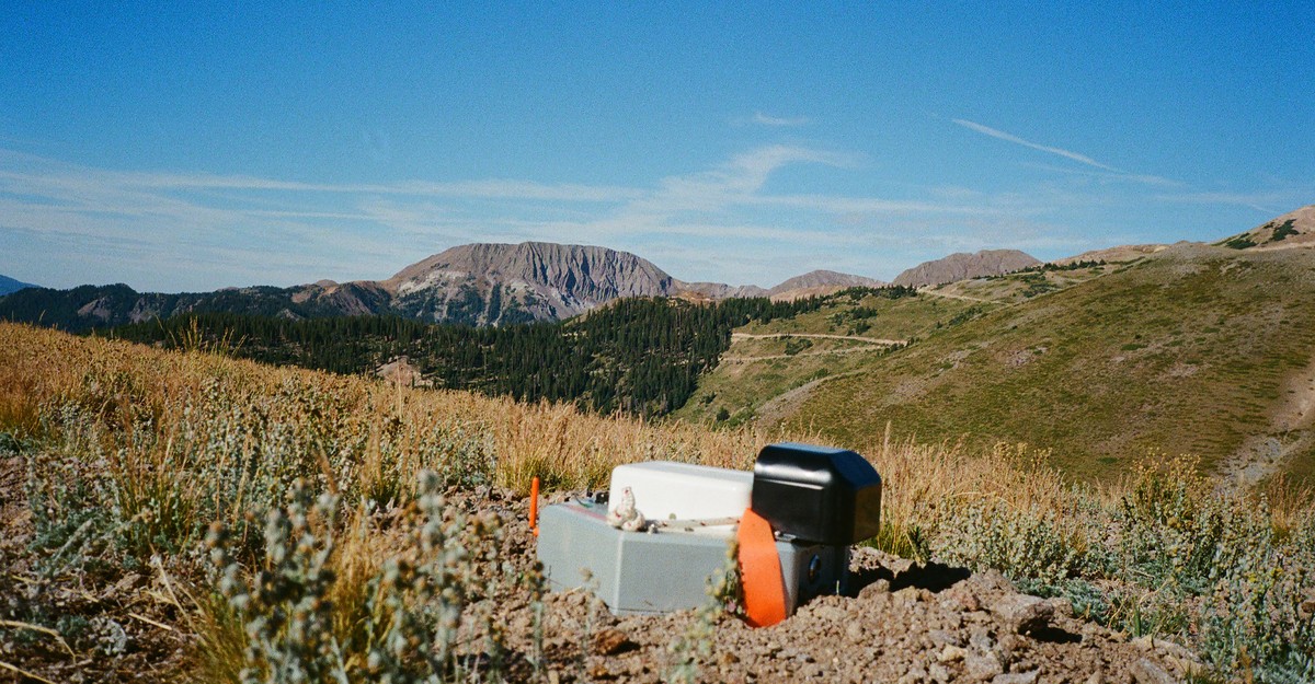
Trevor Katz, a mountain guide leading one of the retrieval teams, held his Garmin GPS device aloft as he navigated the steep terrain. "We should just look for an opening," he said, pointing south while glancing at his colleague Bailey Pugh. After circling through dense branches, they located one node stuck in the dirt, its small antenna and carrying strap protruding above the ground, anchored by a sharp spike below. Pugh pulled it free and packed it away, noting the unusual nature of the find in such remote, high-elevation wilderness.
The guides, including Katz, Pugh, and Levi Warr, were hired through a local guiding company in early summer 2023. An email from a former employer described a client needing "mountain-savvy day workers" for a project meeting at the Deer Trail Mine, located at the eastern base of the Tushar range. Each team received GPS waypoints and instructions to hike the nodes to specific spots, plant them with a pickax in shallow holes, and ensure the geophone-containing spike was buried. "It was really mysterious," Warr told reporters, but the compensation—$500 a day plus per diem—matched their usual guiding rates, so they proceeded.
As the summer progressed, the crew learned more from project geologists and managers: the nodes were collecting seismic data to map underground anomalies potentially rich in gold, copper, nickel, lithium, and other minerals. Manufactured by the Australian company Fleet Space Technologies and released three years ago, the devices connect to low-Earth-orbit satellites to share data for high-resolution "ambient-noise tomography" or ANT surveys. Unlike traditional methods involving booms, hammers, or dynamite to generate seismic waves, these nodes capture naturally occurring earth vibrations and sounds from footsteps, allowing deployment with minimal environmental impact.
The Tushar Mountains, part of the Fishlake National Forest and surrounding Bureau of Land Management territory, offer ideal testing ground due to their geologic history. The American West, including the Colorado Plateau and Rocky Mountains, has long been a hotspot for minerals formed by ancient seas, volcanoes, and tectonic activity. In the 1860s, settlers rushed to the Marysvale area, now home to the Deer Trail Mine, seeking gold, silver, and copper. By the 1930s, most operations had shuttered as shallow deposits were exhausted, though companies periodically attempted revivals.
Helen and Alan Johnson, lifelong Marysvale residents and former Deer Trail Mine employees, recounted the site's turbulent history over lunch at a Mexican restaurant in Orem, Utah. They described a series of failed buyouts, with the most recent in 2018 by Canadian firm MAG Silver, which began traditional exploration before shifting to the Fleet Space nodes for summer surveys. The mine, acquired last fall by another Canadian company, Pan American Silver as part of its purchase of MAG Silver, has seen no further activity to date.
These surveys targeted critical minerals essential for modern technologies—from iPhones and solar panels to combat drones and defense systems. Demand for cobalt, nickel, lithium, and others is surging as the U.S. seeks to reduce reliance on China amid tariffs. The Trump administration, in March 2020, signed an executive order to expedite mining on public lands and streamlined National Environmental Policy Act reviews, eliminating requirements for analyzing hard-to-trace long-term environmental effects.
The Deer Trail project conducted four surveys last summer: an initial regional one covering about 50 square miles across BLM land, national forest, and mine-owned property, followed by three more detailed searches mostly on Forest Service land. Guides like Katz hiked up to 12 miles daily, planting and extracting nodes multiple times. "This is why they had to hire mountain guides," Pugh said, as the team navigated boulders and junipers.
A key question surrounds the lack of permits. No documentation for the ANT surveys was filed with the BLM or U.S. Forest Service, according to a Freedom of Information Act request. The companies involved either declined comment or did not respond. The Fishlake National Forest Ranger Station, which handles Deer Trail communications, stated it had no knowledge of the surveys and expects disclosure for any commercial exploration.
However, a Forest Service national press office spokesperson clarified that such surveys do not require permits or even a formal notice of intent, used to assess oversight needs. Legal experts describe this as a gray area. "The key term is 'significant disturbance,'" said Elizabeth Craddock, a natural resources attorney at Holland & Knight in Washington, D.C. The regulation lacks a clear definition, leaving interpretation open and potentially allowing commercial projects to bypass federal approvals on public lands.
Forest Service rules aim to balance conservation and resource use, distinguishing low-impact activities—like individual gold panning—from commercial operations based on surface disturbance. The nodes' minimal footprint—small holes easily filled or washed away by rain—fits this loophole, enabling quicker exploration. Katz noted that project materials promised hole remediation, though guides did not fill them, leaving faint traces across the landscape.
While the technology promises efficiency, it raises concerns in environmentally sensitive areas. The Tushar range's windswept peaks, including Mount Holly and Delano Peak overlooking Horse Heaven valley, remain pristine, but successful surveys could accelerate mining claims. In Marysvale, where median household income is $28,750 and unemployment hits 63 percent, reopening mines could provide economic relief, aligning with the Forest Service's mandate to sustain rural communities.
Pan American Silver has not pursued further work since acquiring the project, but broader policy shifts suggest momentum. As the U.S. pushes domestic mineral production for national security, non-U.S. firms like the Canadian owners stand to benefit. Guides like Katz cope by hoping development remains distant: "I've been telling myself the little copes that everybody does—that it'll be a long time before this land is developed."
Looking ahead, if ANT nodes proliferate, they could transform exploration nationwide, threading legal gaps to map untapped resources faster. Yet the implications—economic booms in places like Marysvale versus potential scars on public lands—highlight ongoing tensions in America's mineral rush. For now, the Tushar Mountains hold their secrets, with empty holes as subtle reminders of surveys conducted in relative secrecy.