JAMAICA — Hurricane Melissa slammed into Jamaica and Cuba this week, embodying what experts describe as the evolving threat of major storms in an era of climate change. The Category 5 hurricane, which made landfall in Jamaica on Monday and then in Cuba the following day, intensified at a staggering pace over unusually warm Caribbean waters, dumping torrential rains and tying records for its ferocity.
The storm's path and behavior highlight a troubling pattern: hurricanes that strengthen rapidly, stall to unleash massive rainfall, and strike later in the season. According to meteorologists, these characteristics are becoming more common as global temperatures rise, driven by human-induced climate change. Melissa formed in late October, a time when hurricane activity traditionally begins to wane, yet it exploded from a tropical storm to Category 4 status in just 18 hours on Sunday, reaching Category 5 early Monday with sustained winds that made it the strongest Atlantic landfall on record.
Shel Winkley, a meteorologist at the nonprofit research group Climate Central, pointed to the storm's rapid intensification as a key indicator of broader shifts. “These storms aren’t the same storms as a couple decades ago,” Winkley said. He attributed Melissa's explosive growth to sea-surface temperatures in the Caribbean that were 2.5 degrees Fahrenheit warmer than usual, conditions that climate change made up to 700 times more likely.
“Two-and-a-half degrees Fahrenheit may not sound like a lot when it comes to a giant hurricane, but small temperature differences can really make a big impact,” Winkley explained.
The National Hurricane Center defines rapid intensification as an increase in sustained wind speeds of at least 35 mph over 24 hours. Melissa far exceeded that, with Winkley noting that it even surpassed the best forecasts for wind speed. This pattern isn't isolated; recent hurricanes like Milton in 2023, which saw winds jump 90 mph in about 25 hours, and Ian in 2022, which underwent two rounds of rapid intensification before hitting Florida, follow suit. Others include Idalia in 2023, Ida in 2021, and Harvey in 2017.
Phil Klotzbach, an atmospheric scientist at Colorado State University who studies hurricanes, said that while the global number of hurricanes and tropical cyclones has decreased since 1990, activity in the Atlantic has risen. “We find that the number of hurricanes globally, including typhoons, has gone down significantly since 1990,” Klotzbach said. He attributed the Atlantic uptick primarily to a decades-long trend toward La Niña conditions, which weaken high-altitude winds that typically inhibit hurricane formation.
“La Niña is good for the Atlantic if you like hurricanes,” Klotzbach added. Despite fewer storms overall, those that do form are more prone to becoming major ones, reaching Category 4 or 5. Melissa marked the third Category 5 hurricane of the year, the first time in two decades that more than two such powerful storms have occurred in a single Atlantic season.
Zachary Handlos, an atmospheric scientist at the Georgia Institute of Technology, offered a nuanced view on future trends. He said warmer seas will likely foster more hurricanes, but a warmer atmosphere could alter high-altitude winds in complex ways—strengthening in some areas and weakening in others. “It’s not a very straightforward answer,” Handlos said, noting that this remains an active area of research with ongoing scientific debate.
The timing of Melissa's arrival, just days before Halloween, underscores another emerging trend: a lengthening hurricane season. Derrick Herndon, a researcher in the Tropical Cyclone Research Group at the University of Wisconsin, observed, “We’re pretty late into the season at this point. Things should be starting to wind down.” Traditionally, Atlantic hurricane activity peaks in early September, but data from 1971 to 2022 suggests seasons are starting earlier and extending later.
Klotzbach, who recently submitted research on this trend for peer review, linked it to the La Niña pattern, influenced by both climate change and natural variability. This setup weakens winds in the fall when Caribbean waters remain hot, “loading the dice toward these robust hurricanes,” he said. Herndon added that the Caribbean has long been a hotspot for late-season storms, but they're becoming even more likely.
Andy Hazelton, a hurricane modeler and associate scientist with the University of Miami’s Cooperative Institute for Marine and Atmospheric Studies, explained how elevated ocean heat contributed to Melissa's strength. In the past, storms would churn up cooler water from below, limiting their growth. But this year, heat extended as deep as 200 feet, so Melissa “simply churned up more heat and energy,” Hazelton said.
Another hallmark of Melissa was its sluggish movement, stalling off Jamaica's coast and moving at just 2 mph on Tuesday morning before landfall. This allowed it to dump up to 30 inches of rain in parts of Jamaica—more than a third of the island's annual average. A study published last year found hurricanes are more likely to stall near landfall, while other research indicates an overall slowdown in forward speed, though this is debated among scientists.
Some experts theorize that weakened atmospheric circulation patterns due to climate change are behind the slower speeds. The consequences can be devastating, as seen with Hurricane Harvey in 2017, which stalled over Houston and dropped about 5 feet of rain in spots. Winkley highlighted the role of warmer air: “For every 1 degree Fahrenheit of warming, the atmosphere can hold onto 4% more moisture,” he said. “Warmer oceans not only boost the intensity of hurricanes, but it allows for more evaporation, so it’s putting more of that rain-making moisture into the atmosphere for these hurricanes to absorb and then unleash.”
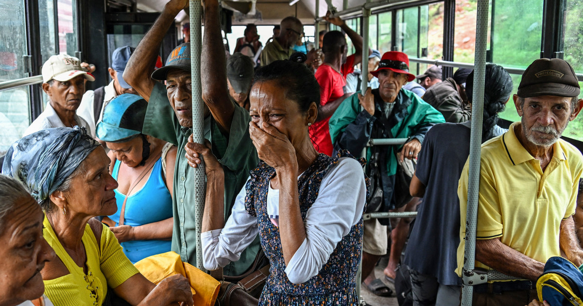
As Melissa serves as a stark example of these evolving patterns, forecasters and officials in vulnerable regions are adapting. The storm's impacts were felt immediately, with widespread flooding and damage in Jamaica and Cuba, though exact casualty figures and economic losses are still being assessed. Experts like Winkley emphasize that understanding these changes has life-or-death implications, urging better preparedness for rapid intensification and prolonged rainfall.
Looking ahead, the scientific community continues to grapple with uncertainties. While Atlantic activity has increased, global trends show a decline, and future projections depend on how climate factors interplay. As Klotzbach noted, the decrease in Pacific cyclones offsets some Atlantic gains, but the rise in major storms demands attention. With Melissa tying the record for the strongest Atlantic landfall and marking a late-season powerhouse, it underscores the need for ongoing research and resilient infrastructure in storm-prone areas.